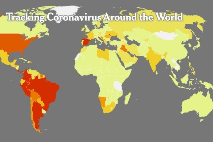
Google has added locality-specific COVID-19 infection data to its branded online maps. The service will warn about the average number of new disease cases in seven days per 100 thousand people.
Over the past ten years, online Google Maps has evolved from a regular navigation service to a complete everyday travel guide.
Using this application, you can find out how to get to work or home, bypassing traffic jams, whether your favourite restaurant is open now, or, as a last resort, read the schedule of public transport in an unfamiliar city.
During the COVID-19 pandemic, user safety became especially important for Google developers, so its representatives decided to add data on coronavirus infections in a specific area to their online mapping service.
Earlier, Google introduced functions to track the highest activity in public places and alerts about areas in which movement may be restricted due to quarantine.
Recently, Google Maps added the ability to view the number of COVID-19 infections in a specific map location. To do this, click on the “Card Type” icon in the upper right corner of the page and select “COVID-19 Information”.
The service will automatically highlight the places on the map with the highest number of coronavirus infections in red. The new feature takes into account the average number of new COVID-19 cases per 100,000 people over the past seven days in the area of the map you are viewing.
A corresponding label will also appear on the maps, informing about the increase or decrease in the number of infections. Google says the data is relevant for all 220 countries and territories that their mapping service supports.
“The data comes from several reputable sources, including Johns Hopkins University, The New York Times and Wikipedia. These sources receive data from public health organizations such as the World Health Organization, government health ministries, and state and local health agencies and hospitals,” Google said.
Recall that a few weeks ago, Google launched the ShakeAlert system for tracking earthquakes around the world through Android gadgets. The system uses accelerometers built into mobile devices to determine seismic activity.
“Your Android smartphone can be part of an earthquake alert system wherever you live. This means that an Android smartphone could be a mini seismometer, joining millions of other Android phones to form the world’s largest earthquake detection network,” Google said.
Upon receiving suspicious accelerometer data, each smartphone with this system will send a signal to the Google server. ShakeAlert will determine the device’s location and compare the data with calls from other Android gadgets in this region.
Additional widgets “Earthquake” and “Earthquake near me” will appear in Google search results, with the help of which users can find up-to-date information about their region and receive instructions on what to do.


Leave a Reply